
      
  
From: Canright, Shelley
Sent: Wednesday, August 19, 2009 7:02 AM
Subject: Emerald Isle Bridge is now a passing image
Gang:
I have taken some
photos of the Emerald Isle bridge as we approached it at
sunrise this morning (6:30am). I realize that my skeptic
colleagues shall claim that is not sufficient proof that
indeed this trip is for real... especially if the evidence
is being submitted by me. So, I encourage Katie to help this
situation....by obtaining any supporting evidence so that
may be a comparison of captured images can prove that indeed
'Now We're Ready' exists, this trip is for real and Emerald
Isle is now a fleeting image on the horizon.
Full throttle, ahead,
mates!
- The Admiral
From: Katie
Sent: Wednesday, August 19, 2009 7:02 AM
Subject: RE: Emerald Isle Bridge is now a passing image
You shall, my friend,
approach another bridge ahead (Atlantic Beach, at which
point you will have seen Emerald Isle from end to end. We
are about mid-way between the two bridges, near a water
tower (Bouge Banks - but I doubt you can read it from the
water) on the ocean side of the island. It’s a lovely day as
you make your way into the sunrise!
From: Katie
Sent: Wednesday, August 19, 2009 7:08 AM
Subject: RE: TARGET:: Emerald Isle (NC) -- At First Light
(August 19)
It's a beautiful
morning for a ghost ship to begin it's voyage through the
Bouge Sound. Ah so fitting, for NC with the stories of
pirate ghosts still wondering open waters protecting their
sunken treasures. The wind has picked up a bit and there are
a few puffy clouds, the water has a slight chop to it this
morning which is different from the past two mornings. The
water has been smooth as glass and Caribbean blue. The odd
thing about being on Emerald Isle is that the sun rises at
one end of the beach (so Shelley is headed straight into it
this morning) and sets at the other end. The orientation is
such that the island is not "north-south" as one would
expect the sun to rise out of the ocean and set behind the
sound.
While the Admiral and
crew were touring by the glimmer of red and green beacons,
my crew was on the beach! We picked up some tiki torches and
took the grill out the beach. We make a makeshift buffet
table with plywood and deck chairs. My brother cooked up
corn on the cob, veggie kabobs, shrimp, scallops, chicken,
and lobster. We finished the evening roasting marshmallows
for smores by the glitter of stars from the sky, firelight
from the tikis and the hush of the ocean.
We were pleased to hear
that Bill's ocean namesake had agreed to stay far off shore
-- we would rather only leave the island with the
Sunday-Sunday rental convoy as opposed to the entire island
and areas inland!
Time for a bike ride --
although I doubt I can make it to the Atlantic Beach Bridge
before Shelley!
From: Detroye, Diane
D.
Sent: Wednesday, August 19, 2009 8:46 AM
Subject: RE: TARGET:: Emerald Isle (NC) -- At First Light
(August 19)
HA!!
The mystery
deepens....the supposedly clandestine bypass of Emerald Isle
and the Pruzan clan lends further credence to the growing
rumor that this whole sojourn is simply a ruse by Shelley
and Michael to be able to cocoon together in their Capital
Hill digs.
In the picture of The
Admiral "at the helm", was anyone else curious about the
small "Washington Marina" sign in the background?
<grin>
From: Katie
Sent: Wed Aug 19 20:42:31 2009
Subject: RE: TARGET:: Emerald Isle (NC) -- At First Light
(August 19)
Even though this Pruzan
didn't actually see the boat -- My mother-in-law saw the
ghost ship as it passed her house this morning! I asked her
if she saw a houseboat while she was having coffee this
morning on her porch. Oddly enough -- she said yes, it was
named something like "Now We're Movin" and it had red swirly
looking things on the outside. They live at water marker 26
in the broad creek area of Bouge Sound (between the Emerald
Isle and Atlantic Beach bridges. They are right on the water
and the eyes of the Pruzans were upon the Admiral's vessel!
Cheers!
From: Canright,
Shelley
Sent: Wednesday, August 19, 2009 8:51 PM
Subject: Re: TARGET:: Emerald Isle (NC) -- At First Light
(August 19)
Yippee...proof that
this is NOT a hoax! A hug to your mother-in-law!
From:
Anderson, Bill
Sent: Wednesday, August 19, 2009 5:46 PM
To: Canright, Shelley
Subject: How's it going?
Haven’t heard much from you today. Everything OK?
From:
Canright, Shelley
Sent: Wednesday, August 19, 2009 7:25 PM
To: Anderson, Bill
Subject: RE: How's it going?
We
were paddlin’ much of the time where there was limited to no
connectivity. We actually docked early today…around
3:30pm. Stopped for gas and decided to check to see what
might be next stopping point so not to have a repeat from
last night. We learned that we would have to travel another
five hours…and that would be WAY into darkness. So, nope,
we dropped anchor in small NC community of Bellhaven. We
have just returned from driving golf cart to town and doing
dinner. I am now in the process of downloading
email…writing up Admiral’s Log and sorting through photos
taken today to accompany the log. Stand by, First Mate.
:-)
Admiral’s Log
Wednesday, August 19
A quick recap from last night is in order. We were
successful in making passage through the three low bridge
obstacles that had faced us at the beginning of the day,
with the last obstacle being overcome near sunset at 8pm.
We now found ourselves in situation that dusk would soon be
upon us and with no place to anchor, we would need to
continue into the night for some unknown period of time. We
decided to remain calm at this realization and just absorb
the moment and everything that was to grace us during this
paddling time.
Beautiful sunset across our aft deck was captured. And we
did in fact see some most interesting things come to life
during the next one and one-half hours until we found a safe
haven at Caspers Dry Dock Marina. In the growing darkness
we witnessed the Marines conducting war games with
helicopters and flares bursting into the night sky. We were
offered our own personal ‘firework display’ underneath a
sky full of stars. (PHOTO #385, 386)
.jpg)
Photo 385: As the Sun Sets, Another Day Paddlin'

Photo 386: Marine Maneuvers at Dusk
This new day came all too quickly, but by now we were more
quickly getting our act together and within 30-minutes of
wake-up, we were underway pre-dawn. We believe our little
vessel is beginning to get the whiff of river water up
ahead! We took are anxious for the water of the Potomac
River. Good bye to Caspers as we paddle in the direction of
sunrise. (PHOTO #387)
.jpg)
Photo 387: First Light Leaving Caspers (Night Stop)
It is with a heavy heart that the Admiral must reveal that
rumors can be heard from envious landlocked persons that
there is growing disbelief that this adventure is real and
like a reality television show, much of this is staged. One
person has even suggested this is like the great Moon Hoax
and is calling for substantiated evidence other than that
which the Admiral supplies through daily logs and photos!
NAMELESS SOURCE
STATES, “We have yet to see independent confirmation that
this journey is happening (think faked Moon landings) and
it's not just Shelley and Michael having a grand 'ole time
at their Capital Hill home with elaborate use of backdrops,
props, and random tourists shanghaied from Union Station.
Skepticism will abound if all you capture is a grainy
B-Berry photo.”
Jumping into the deep end of this discussion was individual
that happened to be vacationing close to where the houseboat
was projected to pass on this day and offered to be on hand
to offer photo evidence or any needed supplies.
Needless to say, the passage of this vessel beneath the
Emerald Isle Bridge (at Swansboro, NC) occurred just at
sunrise and thus the opportunity to quiet the mutterings was
not to happen. Sunrise at the bridge was photographed, but
I guess some would claim that such a bridge and sunrise
could have happened over any such bridge on the Potomac
River, near Washington, DC. (PHOTO #389)
(Sunrise).jpg)
Photo 389: Emerald Isle Bridge - Half Mile Away - Sunrise
Perhaps the next opportunity to quell these rumors shall be
as we get close to Norfolk, VA and the ‘family’ at NASA
Langley shall bear witness.
Today’s journey has taken us up the NC coast from
Swansboro, past Morehead City and Atlantic Beach and then
across section of the Pamlico Sound towards Oriental, NC.
Navigation across the Sound was done by our most proficient
Captain Rob and his best friend at that time, a handheld
GPS. (PHOTO #404 and 405)
.jpg)
Photo 404: Rob Charts Course (GPS)
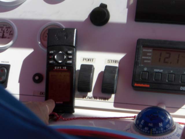
Photo 405: Rob Does His Magic
Jewel of the nearest east is how Oriental is described.
Framed by the rivers and streams of lower Pamlico Sound,
Oriental faces the Outer Banks with a soul linked to the
traditions of coastal exploration. The population is
small...and by all observations…the folks would like to keep
it that way. The settlement lacks many of the conveniences
that us city slickers have come to expect…but that’s much of
the charm of this town. In Oriental you could move on at
your own pace – or not at all. For us, we have chosen to
move on….
FUEL STOP
We moved only as far as
Belhaven, today. We stopped here for fuel at 3:30pm and
inquired what laid between this community and the next
community – about 50 miles or 5 hours from this spot. We
were told, nothing, except for water, wind, shoals and
limited locations where one might anchor for the night. We
made decision to settle down early with plans to have a much
earlier start in the morning.
This is the first
opportunity since the start of this little adventure that we
have been able to have some daylight and actually explore a
community. The translation of the word Belhaven means
‘beautiful harbor’. Up the walkway from where we have
docked is the Manor House. It is from the back steps of
this Manor that free wireless internet can be found…and I
did! (PHOTO #419)

Photo 419: Belhaven Manor House
Belhaven has two traffic
lights and folks tend to get around on an array of four
wheel vehicles, from trucks, to skate boards…and, in our
case, golf cart. The dock master provided us an electric
cart which we used to cruise down the road for dinner at the
recommended restaurant – The Fish Hooks Café. Michael drove
and found that the brakes were ‘squishy’ and we had a few
close calls when we came up to a stop sign, braked hard, and
finally came to a stop in the middle of intersection.
Dinner was wonderful and the town quaint. See for
yourself! (PHOTOS 410, 411, 414)
.jpg)
Photo 410: Evening Transportation to Town
.jpg)
Photo 411: Mr. Crabby, Belhaven, NC
.jpg)
Photo 414: Community Pond, Belhaven, NC
.jpg)
Photo 408: Night Stop, Belhaven, NC
Good night from sleepy
Belhaven, mates!
Total distance: 92
miles Total time: 9 hours
|